

UN Votes to Correct World Map and Show Africa in Its True Size
The United Nations has given an African-led campaign to redraw the world’s visual geography a major diplomatic victory, backing a new map projection designed to show the continent at a scale closer to its actual size.
According to the BBC, the UN General Assembly adopted the “Correct the Map” resolution on Friday, September 4, with 164 countries voting in favor, six abstaining and only the United States voting against. Led by Togo on behalf of the African group and supported by the African Union, the resolution encourages governments, international organizations, schools and other institutions to move towards map projections that better represent the relative size of the world’s regions.
The vote is not simply about replacing one graphic with another. At its heart is an argument over how geography shapes perception, and whether a map that has dominated classrooms, atlases and public life for centuries has also helped create a distorted picture of Africa’s place in the world.
Why the Mercator map became controversial
The Mercator projection was created in 1569 by Flemish cartographer Gerardus Mercator, primarily to assist maritime navigation. Its great strength was its ability to preserve directions and angles, making it useful to sailors plotting routes across the oceans.
Its weakness is that it badly compromises the apparent size of land masses, particularly as they get closer to the North and South Poles.
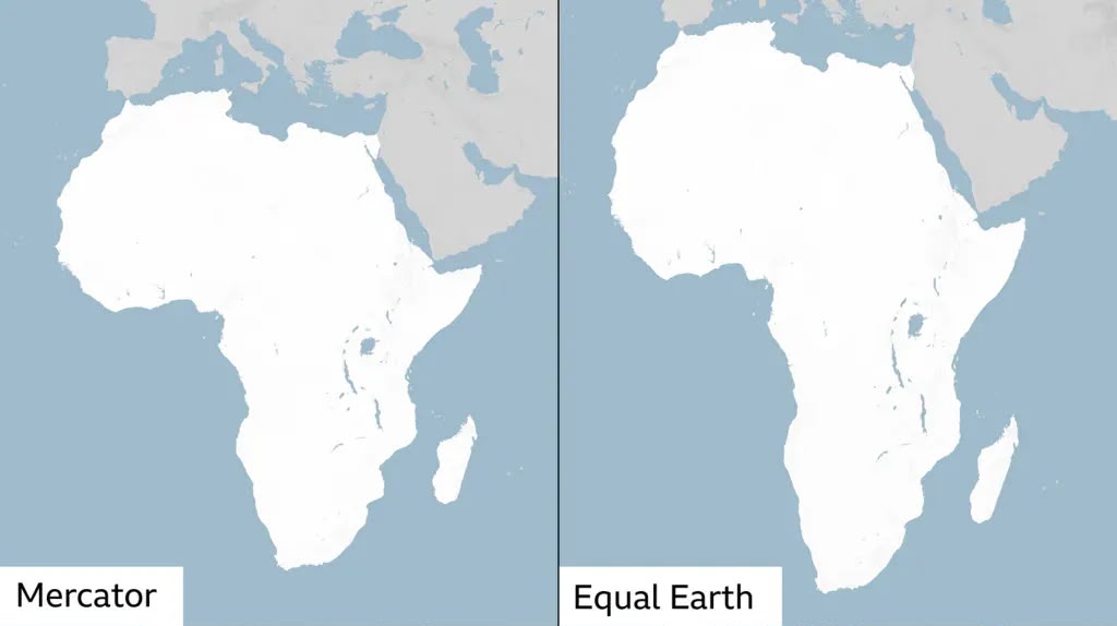
Africa, which straddles the equator, is therefore displayed considerably smaller than its actual area. Greenland can appear almost comparable to Africa on a conventional Mercator map, although Africa is roughly 14 times larger.
That distortion is not a mistake in the simple sense. There is no way to flatten a spherical planet onto a rectangular sheet without introducing some form of distortion. The real question is what a particular map chooses to preserve and what it sacrifices.
For decades, however, the Mercator projection became so familiar that its visual distortions were often mistaken for geographical reality.
The Equal Earth projection, developed in 2018 by cartographers Tom Patterson, Bojan Šavrič and Bernhard Jenny, takes a different approach. It is an equal-area projection, meaning the relative areas of continents and countries are preserved far more faithfully, although shapes and distances cannot all remain perfectly accurate.
The African Union endorsed Equal Earth in February as part of its campaign to promote a more accurate representation of the continent. The UN resolution now gives that campaign an international platform.
Beyond cartography, a battle over perception
The political argument surrounding the campaign is more consequential than the technical debate among cartographers.
For advocates, the problem is not that Europeans or North Americans deliberately designed the Mercator projection to make Africa appear insignificant. Its original purpose was navigation, not propaganda.
But the campaigners argue that centuries of repeated exposure to the same distorted image can influence how people instinctively understand the world.
“A fair world begins with a fair map,” Togo’s Foreign Minister Robert Dussey said ahead of the vote.
The argument is particularly relevant for Africa, a continent covering about 30 million square kilometers and containing 54 countries. Its geographical scale, natural resources, population and economic diversity are difficult to appreciate when it is routinely displayed beside much smaller regions in maps that exaggerate areas farther from the equator.
Lerato Mogoatlhe of Africa No Filter described the issue as a narrative problem, arguing that Africa’s visual misrepresentation contributes to longstanding misconceptions about the continent.
Kenyan geographer Kioko Muendo similarly argues that maps influence political and economic perceptions, not merely navigation. That makes the campaign part of a wider African effort to challenge inherited narratives about the continent.
Why the US opposed it
The overwhelming vote also exposed a striking disagreement between the United States and most of the international community.
The United States was the only country to vote against the resolution. Its representative criticized the initiative as an ideological exercise that distracted the General Assembly from more pressing international issues. The objection reflects a broader US concern about UN resolutions addressing historical injustice, reparations and what supporters call “cognitive justice.”
Yet the result left the US isolated on the issue, with 164 countries backing the resolution.
France and other European countries have also shown support for changing the way Africa is represented. French Foreign Minister Jean-Noël Barrot has said France would move away from the Mercator projection, adding another layer to the campaign’s symbolic importance.
What actually changes?
The UN vote does not ban the Mercator projection, nor does it mean every map in the world will suddenly change.
The resolution is non-binding. Its real impact will depend on whether governments, schools, publishers, media organizations and technology companies actually alter the maps they use. The challenge may be greatest in digital mapping, where established platforms and navigation systems have technical reasons for retaining different projections.
Still, the significance of Friday’s vote lies precisely in that shift from familiarity to scrutiny.
The world will not become geographically different because a map changes. Africa was always the size it is.
What can change is the image people carry in their heads.
And that is ultimately what the “Correct the Map” campaign is trying to address: not the physical geography of Africa, but the centuries-old picture of it that the world has become accustomed to seeing.